Taiwan Security Monitor

Visualization: Potential US Missile Deployment Locations in the Philippines

Authors: Chris Dayton & Ethan Connell

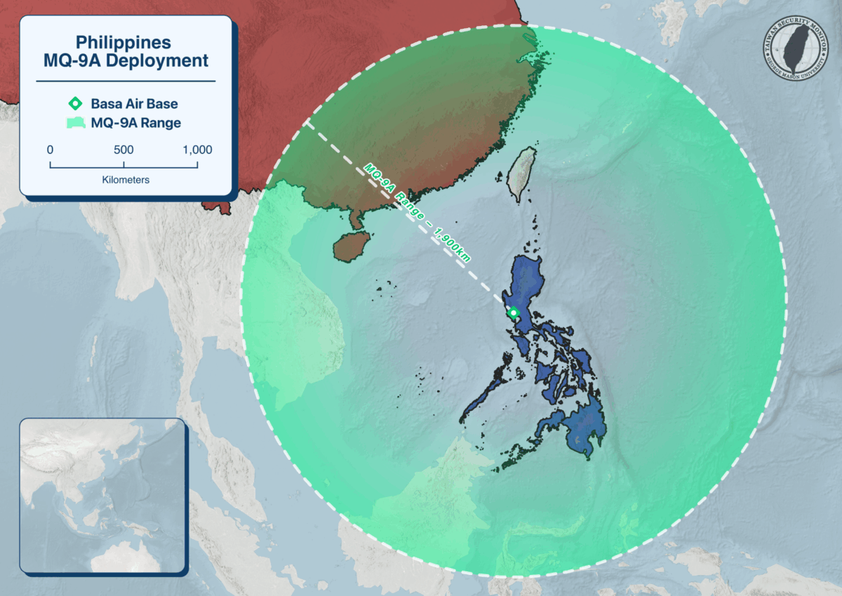
Per USNI News, U.S. and Philippine defense officials have committed to increasing missile and drone deployments across the archipelago as part of broader First Island Chain deterrence efforts, with recent rotations spotlighting Northern Luzon and the Batanes areas nearest Taiwan. Above is our visualization of potential U.S. missile deployment locations in the Philippines and the approximate engagement envelopes for NMESIS (180 km), Typhon/MRC (450 km), and HIMARS (500 km).

Visualization: New Philippine Navy Monitoring Detatchment at Tubbahta Reef

Authors: Chris Dayton & Ethan Connell


The Philippine Navyโ€™s Western Naval Command will stand up a Naval Monitoring Detachment at Tubbataha Reefs Natural Park, with the stated goal of improving patrol, surveillance, and rapid-response coverage of Chinese naval activity in the Sulu Sea, while also supporting the reef’s protection against illegal activity. Above is our visualization of the detachment’s proposed location:

Visualization: Taiwan’s Varied Aircraft Protection


Authors: Chris Dayton & Noah Reed


Recent drone attacks on airfields in global conflicts have placed a heightened focus on aircraft protection at Taiwanโ€™s major military bases. Improving ROCAF survivability is now a priority for the MND, with plans to significantly expand hardened shelters at Chihhang AFB by 2028 to protect future F-16C/D Block 70 fighters. Above is our visualization of the level of hardened protection at each of Taiwanโ€™s airbases.

Visualization: Planned HIMARS Deployments on Outlying Islands

Author: Chris Dayton


Taiwan’s military reportedly plans to deploy its recently acquired HIMARS launcher platforms to its outlying islands of Penghu and Dongyin, a move that could put many of China’s coastal naval facilities and airfields in Fujian and Zhejiang provinces within range of Taiwanese missiles. This comes after reports that Taiwan intends to expand its M142 HIMARS inventory to 111 launchers in future material purchases from the United States. Our visualization shows possible deployment locations and the operational range of HIMARS munitions in Taiwan’s inventory.

Visualization: Taiwan’s Energy Import and Storage Vulnerabilities

Author: Chris Dayton


During the recent Justice Mission-2025 exercises around Taiwan, a key focus was rehearsing a blockade of Taiwanโ€™s major energy import facilities. Taiwan imports nearly 96% of its energy, primarily oil and LNG.

Our visualization shows the locations of Taiwan’s energy import and distribution facilities alongside live-fire zones from recent joint exercises around the island.

Visualization: Philippines MQ-9A Deployment

Author: Chris Dayton


Per Aaron-Matthew Lariosa, the U.S. Marine Corps temporarily deployed a unit of MQ-9A drones to Basa Air Base in the Philippines beginning in 2024, supporting Philippine intelligence collection in the South China Sea and providing surveillance assistance of maritime threats.

Above is our visualization of Marine Unmanned Aerial Vehicle Squadron (VMU) 1’s deployment and the MQ-9A’s operational range:

    Visualization: Brahmos Missile Deployment

    Author:ย Chris Dayton, Ethan Connell


    The Philippine Marine Corps publicly unveiled its BrahMos cruise missile coastal defense system at a Marine Corps Coastal Defense Regiment facility in Zambales.

    Above is our visualization of the BrahMos system’s deployment site and reported operational range.

    Visualization: Taiwan Military Theatre Command

    Authors: Chris Dayton, Noah Reed


    In 2021, Taiwan’s military reorganized its command structure into several “operational zones” (ไฝœๆˆฐๅ€), also often called “operational theaters” . These zones represent the integrated command of Taiwan’s different armed services.

    Recently, Taiwan’s MND announced each command will have an integrated UAV battalion by 2026. Our visualization shows the breakdown of each command’s territorial jurisdiction.

    Visualization: Deployment of U.S. Typhon Missile System in Japan

    Authors: Chris Dayton, Joe O’Connor


    On September 15, a U.S. Typhon Missile System, capable of firing the Tomahawk Land Attack Missile (TLAM), was deployed to Marine Corps Air Station Iwakuni in southern Japan. This marks the first deployment of Typhon to Japan, and the platform will take part in the currently ongoing Resolute Dragon 25 exercise.

    Below is our visualization of the Typhonโ€™s deployment location and operational range.

    Visualization: Delared Scarborough Shoal “Natural Nature Reserve”

    Author: Chris Dayton


    Following an incident on August 11th between a PLAN/CCG vessel and a Philippine Coast Guard vessel near Scarborough Shoal, the PRC recently announced the creation of a “national nature reserve” surrounding a portion of the Shoal.

    Our visualization shows the core and experimental areas, which respectively limit certain activities within their areas.