Taiwan Security Monitor

Visualization: US Military Aircraft Training Incident


Author: Maxwell Hollingsworth


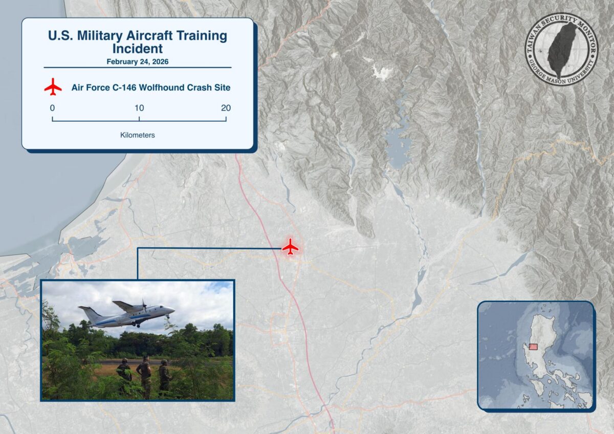
On Feb. 24, a U.S. Air Force C-146 Wolfhound struck a concrete road barrier while attempting to take off from a designated alternate landing zone on a bypass road in Laoac, Pangasinan, during contingency training with Philippine counterparts, injuring all five personnel onboard. 

This was the first such alternate roadway landing activity in the Philippines, tied to both contingency operations and humanitarian/disaster response scenarios. 

Above is TSM’s visualization of the incident’s location.

Visualization: Potential US Missile Deployment Locations in the Philippines

Authors: Chris Dayton & Ethan Connell

Per USNI News, U.S. and Philippine defense officials have committed to increasing missile and drone deployments across the archipelago as part of broader First Island Chain deterrence efforts, with recent rotations spotlighting Northern Luzon and the Batanes areas nearest Taiwan. Above is our visualization of potential U.S. missile deployment locations in the Philippines and the approximate engagement envelopes for NMESIS (180 km), Typhon/MRC (450 km), and HIMARS (500 km).

Visualization: New Philippine Navy Monitoring Detatchment at Tubbahta Reef

Authors: Chris Dayton & Ethan Connell


The Philippine Navyโ€™s Western Naval Command will stand up a Naval Monitoring Detachment at Tubbataha Reefs Natural Park, with the stated goal of improving patrol, surveillance, and rapid-response coverage of Chinese naval activity in the Sulu Sea, while also supporting the reef’s protection against illegal activity. Above is our visualization of the detachment’s proposed location:

Visualization: Philippines MQ-9A Deployment

Author: Chris Dayton


Per Aaron-Matthew Lariosa, the U.S. Marine Corps temporarily deployed a unit of MQ-9A drones to Basa Air Base in the Philippines beginning in 2024, supporting Philippine intelligence collection in the South China Sea and providing surveillance assistance of maritime threats.

Above is our visualization of Marine Unmanned Aerial Vehicle Squadron (VMU) 1’s deployment and the MQ-9A’s operational range:

    Visualization: Brahmos Missile Deployment

    Author:ย Chris Dayton, Ethan Connell


    The Philippine Marine Corps publicly unveiled its BrahMos cruise missile coastal defense system at a Marine Corps Coastal Defense Regiment facility in Zambales.

    Above is our visualization of the BrahMos system’s deployment site and reported operational range.

    Visualization: Delared Scarborough Shoal “Natural Nature Reserve”

    Author: Chris Dayton


    Following an incident on August 11th between a PLAN/CCG vessel and a Philippine Coast Guard vessel near Scarborough Shoal, the PRC recently announced the creation of a “national nature reserve” surrounding a portion of the Shoal.

    Our visualization shows the core and experimental areas, which respectively limit certain activities within their areas.

    Visualization: New AFP Forward Operating Base Mahato

    Author: Noah Reed


    The Philippines has opened a new forward operating base in Mahatao, Batanesโ€”just 120 miles from Taiwan. Our graphic shows its location in the Luzon Strait, a vital chokepoint for regional security.

    Visualization: Map of Scarborough Shoal Collision and Nearby Naval Activity

    Authors: Chris Dayton, Ethan Connell


    On August 11, 2025, a PLAN destroyer and a China Coast Guard cutter collided with each other in the waters around Scarborough Shoal during a close-quarters pursuit of a Philippine government vessel.

    Above is a visualization highlighting the reported collision site and the floating barrier at the shoal, along with USS Higginsโ€™ approximate 8/12/2025 position and estimated track derived from public AIS data.

    Visualization: Map of Territories and Claims in the Spratly Islands

    Authors: Chris Dayton, Ethan Connell


    The PLAโ€™s Southern Theater Command recently undertook live-fire exercises to the north of the Spratly Islands, which they claim under their Nine-Dash Line.

    Above is our visualization of the administration of those features along with Chinaโ€™s claims, highlighting a May 21st incident in which a China Coast Guard ship sideswiped and water-cannoned a Philippine government vessel in the waters around Sandy Cay.

    Visualization: AFP Northern Luzon Facilities and Deployments

    Author: Chris Dayton, Ian Struble, Ethan Connell


    As Balikatan 2025 continues, AFP Chief of Staff Gen. Romeo Brawner recently underscored the “inevitability” of Philippine involvement in a Taiwan conflict, citing 250,000 overseas Filipino workers in Taiwan.

    The Northern Luzon Command’s strategic position is pivotal, as joint drills with the US intensify near the Bashi Channel and Luzon Strait.

    This map contains all deployed unit land facilities, relevant airfields, and naval bases/facilities.