Taiwan Security Monitor

Visualization: Japan P-1 Patrol Aircraft Deployment


Author: Maxwell Hollingsworth


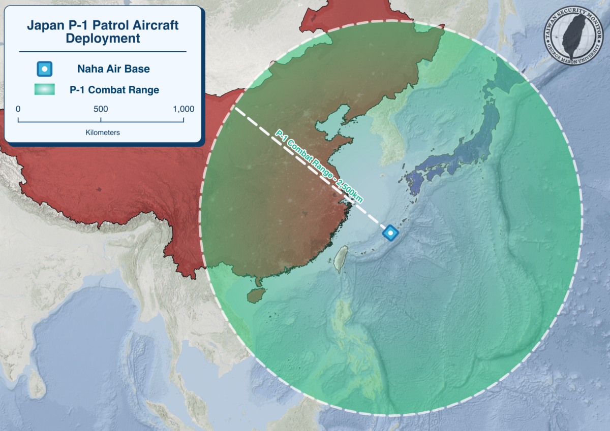
Japan has begun deploying its domestically constructed P-1 maritime patrol aircraft to Naha Air Base for the first time, with 10 aircraft expected by FY2027 to replace aging P-3C Orions. 

Above is our visualization of the P-1’s deployment at Naha Air Base and its operational range.

Visualization: Japan’s First Island Chain Military Infrastructure

Authors: Noah Reed and Joe O’Connor


Recently, comments by Japanese PM Sanae Takaichi regarding China and the announcement of surface-to-air missiles being deployed at Yonaguni Island have attracted attention and discussion about Japanese military infrastructure in the First Island Chain.

Above is our visualization of JSDF facilities in the First Island Chain, including Okinawa.

Visualization: Yonaguni Missile System Deployment

Authors: Noah Reed, Joe O’Connor


Today, Japanese Minister of Defense Shinjiro Koizumi visited Yonaguni, the westernmost Japanese island in the Senkakus. After inspecting a JGSDF garrison, Koizumi announced that the JSDF will deploy a Type 03 Chลซ-SAM missile battery on the island, to โ€œreduce the likelihood of an armed attack against our country.โ€ The Type 03 has an effective range of approximately 50 km, while Yonaguni itself is approximately 105 km from Taiwan.

Above is our visualization of the Type 03’s future deployment on Yonaguni.

Visualization: Deployment of U.S. Typhon Missile System in Japan

Authors: Chris Dayton, Joe O’Connor


On September 15, a U.S. Typhon Missile System, capable of firing the Tomahawk Land Attack Missile (TLAM), was deployed to Marine Corps Air Station Iwakuni in southern Japan. This marks the first deployment of Typhon to Japan, and the platform will take part in the currently ongoing Resolute Dragon 25 exercise.

Below is our visualization of the Typhonโ€™s deployment location and operational range.

Visualization: New Type-12 and HVGP Missile Deployment Locations

Author: Chris Dayton

Research: Ethan Connell


On August 29, Japan’s Ministry of Defense announced the deployment locations of improved Type 12 surface-to-ship missiles, as well as their Hyper Velocity Glide Projectiles (HVGP). Below is a TSM map showcasing those locations and the maximum range of those missiles.

Visualization: Japan’s Lower Island Evacuation Strategy

Author: Ian Struble, Chris Dayton

Research: Olivianna Watkins, Graham Coughlan


In March, the Japanese government announced plans to evacuate up to 120,000 civilians from the Sakishima Islands, part of Okinawa Prefecture, in the event of a Taiwan contingency.

This map is a visualization of those plans, showing the impacted islands and evacuation routes.